Explore Collections Explore The Collections
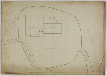
You are here: CollectionsOnline  /  [1] Survey drawing taken by Thomas Dove, 1788
  • image SM 73/3/3

Reference number

SM 73/3/3

Purpose

[1] Survey drawing taken by Thomas Dove, 1788

Aspect

Site plan of The Castle Hill showing The Castle, The Shire House, The Keepers House, Pump, Stairs to Privy, The Road 185 feet and The Bridge 149 feet long and (Soane, feint pencil, some pen) plan and section of proposals to the east of the castle keep

Scale

scale bar of 1/16 inch to one foot

Inscribed

as above, North, South, East, West (west at the top of the sheet), (Soane, pencil, mostly illegible, some words crossed out, relating to securing the bridge and the road) A, B, (marks bridge and road) A. The --- Gate --------- 8 feet high / is & which are to be ----- fixed at ---- / this place as the solid -------- / --- can not be ------- the / Bridge. The Gate is to be -- / --- ------ Ledger ---- braced / B. ------ ------ 8 feet high (remainder illegible) and some (Soane, pencil) dimensions given

Medium and dimensions

Pen, sepia, yellow and green washes, pricked for transfer on laid paper (475 x 674)

Hand

Thomas Dean, surveyor

Watermark

J Whatman, fleur-de-lis within crowned cartouche and below, ornate W

Notes

This survey drawing was made by Thomas Dove, of whom not much is presently known. Norfolk County Record Office has two drawings signed by him and dated 1786 for a new bridewell (prison, house of correction) and a further drawing for alterations and additions to the existing bridewell after a fire (NCR case 1be/100-102). These last were carried out by Dove; the bridewell is now the Bridewell Museum in Bridewell Alley, Norwich.

Soane's office "Journal No1' has an entry for 13 May 1789: 'surveyed Castle'. Presumably he took with him Dove's survey drawings, no doubt originally made for the Norwich City Corporation.

The site plan shows that the area of the 'Castle Hill' was roughly 256 feet by 256 feet and that access was via a bridge to the south and a road to the north-east. Of the three buildings shown, the castle keep had been used as a prison since about 1220 though when purpose-built interventions were made is uncertain. However by 1747-9 Matthew Brettingham (1699-1769) was repairing the keep/prison as well as building the Shire Hall.

Literature

N. Pevsner and B. Wilson, Norfolk 1: Norwich and north-east, 2nd ed.,1997, pp.256-60

Level

Drawing

Digitisation of the Drawings Collection has been made possible through the generosity of the Leon Levy Foundation

If you have any further information about this object, please contact us: drawings@soane.org.uk

Sir John Soane's collection includes some 30,000 architectural, design and topographical drawings which is a very important resource for scholars worldwide. His was the first architect’s collection to attempt to preserve the best in design for the architectural profession in the future, and it did so by assembling as exemplars surviving drawings by great Renaissance masters and by the leading architects in Britain in the 17th and 18th centuries and his near contemporaries such as Sir William Chambers, Robert Adam and George Dance the Younger. These drawings sit side by side with 9,000 drawings in Soane’s own hand or those of the pupils in his office, covering his early work as a student, his time in Italy and the drawings produced in the course of his architectural practice from 1780 until the 1830s.

Browse (via the vertical menu to the left) and search results for Drawings include a mixture of Concise catalogue records – drawn from an outline list of the collection – and fuller records where drawings have been catalogued in more detail (an ongoing process).