Explore Collections

You are here:
CollectionsOnline
/
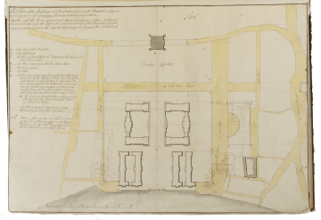
[11/2] Draft block plan of the Greenwich Hospital Buildings and site, c.1728, showing proposals for alterations to the roads and approaches around the Hospital which include a more southerly position for the Romney Road
Browse
Reference number
SM volume 109/6
Purpose
[11/2] Draft block plan of the Greenwich Hospital Buildings and site, c.1728, showing proposals for alterations to the roads and approaches around the Hospital which include a more southerly position for the Romney Road
Aspect
Block plan
Scale
100 feet = 1 3/20 in.
Inscribed
In ink at top left in any unidentified hand the title, A Plan of the Buildings and Foundations of Greenwich Hospitall as they are / now Carrying on and advancing Pursuant to the Original Scheme . / Together with the Road, Grounds and Streets Contiguous to them. As they are / proposed to be altered for the Approaches and Conveniences of the Hospitall and the / adjoining parts as well as the complete Regularity and Security of the said Fabrick; and below on left side, as a table, lettered from A to G, describing the elements of the plan (see Notes); and below this in another hand: Note. That in altering the New Road an Acre / of Ground will be cut off from the Queen's / Garden, and the like Quantity added / at the West End, as was said before; and on plan with names of streets and roads; and with numbered scale bar; and at top right (of volume) in C19 hand, 6
Signed and dated
- Undated but datable c.1728, contemporary with 109/5
Medium and dimensions
Pen and brown ink over prick-marks (from [11/1]; 109/5) and graphite under-drawing, with grey and yellow washes Laid paper, laid down 512 x 732
Hand
Unidentified
Watermark
Strasbourg Lily / 4WR / LVG; IHS / IVILLEDARY
Notes
This block plan is probably contemporary with the engraved 'Plan General of the Royal Hospital of Greenwich' of 1728 in the National Maritime Museum (Wren Society, VI, pl. 15, top). It embodies proposals for replanning of the whole environment around the Hospital, embracing the Queen's House, the Queen's Garden, St Alfege's, and the old town of Greenwich. Like the engraved plan, it develops the scheme indicated in dotted outlines in [11/1] by repositioning the Romney Road to the south. This New Road (called Via Regia on the engraved plan) is wider and aligns with St Alfege's.
The inscription marked G on the left side of the drawing describes how moving the road northwards would result in a loss of an acre of ground from the Queen's Garden. This loss is to be compensated for by extending the garden in a more uniform plan to the west, an alteration shown on the drawing by the deletion of the historic 'Fryers Road' (Friars Road), the line of which is shown on [11/1]. As a result, the Crown will be a gain by this Exchange if his Majesty please to consent and approve of it.
The idea of aligning the Romney Road with the church was part of a broader ambition by Colen Campbell's office to regularise the whole site. One aim was the enclosure of the site with a boundary wall; see [12/1]. The wall has not yet been drawn on the present plan, and the axis on the central west portico of the King William block is still emphasised. This cross axis is marked with a dotted line across the plan and is reinforced in this scheme by the plan of the proposed Infirmary (marked B). This has a large semi-circular recess in its front facade that corresponds to the central range of the King William block. Within Greenwich itself, the plan shows a proposed new service building, marked C. This is the Mews and Out Offices, including a Bakehouse, Brewhouse and other Conveniences.
Literature
Wren Society, VI, pl. 13, bottom
Level
Drawing
Digitisation of the Drawings Collection has been made possible through the generosity of the Leon Levy Foundation
If you have any further information about this object, please contact us: drawings@soane.org.uk