Explore Collections Explore The Collections
You are here: CollectionsOnline  /  [2] Survey drawing of the existing Bank and adjoining properties
  • image SM 9/3/5

Reference number

SM 9/3/5

Purpose

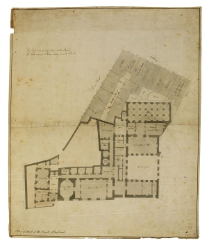
[2] Survey drawing of the existing Bank and adjoining properties

Aspect

Ground plan of the north-west part of the Bank and adjacent properties

Scale

bar scale

Inscribed

The Parts colored red belong to the Bank / The Parts colored Blue belong to Mr Priest, plan of existing Bank labelled: Court yard, Accountants Office, drawing / Accounts Office, deputy Acct Office, Library, Yard, Discount Office, Chancery Office, Mr Edwards Room, Coffee Room, Strong Room, Waiting Room, Water Closet, Yard, Governor's / Room, Barrack Room, Court Room, Committee Room, Office Room, plan of holdings labelled: Catharine Court, Brealy, Passage, Mr Aubin, Clements / China Shop, Price / Cock and Bottle, Bakehouse, Nicholas Baker, Passage, Yard (three times), Butchers, Trunkmaker, Mr Newland / now Mr Mudge, (Bailey) Plan of part of the Bank of England, and dimensions of each holding given

Medium and dimensions

Pen, grey, blue and red washes, and pencil, within single ruled border, on wove paper (645 x 535)

Hand

Soane office

Verso

Drawing has been inlaid on another sheet, but the verso is visible.
insc: Bank of England / Plan of premises / Lothbury [through?] Barth / Lane & c. abutting on the / Bank presented / to the Committee / Decr 27 1792

Notes

The land to the north-east was a warren of houses, courts and passages. In this era of protests and riots, such a dense cluster of buildings so near to the Bank's walls was a source of anxiety. The bill submitted by the Bank to Parliament in 1793 (and approved) referred to the houses' flammability and the "various hazardous trades" that they harboured. This drawing shows the density of the area and its proximity to the Bank. Circulation of traffic was also hampered by the disorderly layout; SM 9/3/2 shows that the north end of Bartholomew Lane was largely obstructed by houses projecting into the street. Once the land was obtained, the streets could be widened and the houses demolished. After Bartholomew Lane was straightened, however, there remained an 'island' of rubble or houses (see SM 9/3/3, SM 9/3/4 and SM 9/3/1). On 12 June 1798 the Building Committee moved to 'pull down the houses on Bartholomew Lane', presumably referring to this last remnant of buildings.

Level

Drawing

Digitisation of the Drawings Collection has been made possible through the generosity of the Leon Levy Foundation

If you have any further information about this object, please contact us: drawings@soane.org.uk

Sir John Soane's collection includes some 30,000 architectural, design and topographical drawings which is a very important resource for scholars worldwide. His was the first architect’s collection to attempt to preserve the best in design for the architectural profession in the future, and it did so by assembling as exemplars surviving drawings by great Renaissance masters and by the leading architects in Britain in the 17th and 18th centuries and his near contemporaries such as Sir William Chambers, Robert Adam and George Dance the Younger. These drawings sit side by side with 9,000 drawings in Soane’s own hand or those of the pupils in his office, covering his early work as a student, his time in Italy and the drawings produced in the course of his architectural practice from 1780 until the 1830s.


Browse (via the vertical menu to the left) and search results for Drawings include a mixture of Concise catalogue records – drawn from an outline list of the collection – and fuller records where drawings have been catalogued in more detail (an ongoing process).