Scale
bar scale of 1 inch to 50 feet
Inscribed
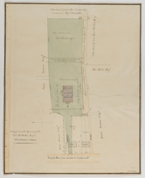
PLAN of part of the ESTATE of the / late Thos: Clutton Esqr:at / WALWORTH in SURRY / Turnpike Road from London to Camberwell. / JOHN ROLLS ESQR: This space is proposed to be purchased & added / to the entrance / Offices / House / Garden &c. Houses / Gardens / ROAD / JOHN ROLLS ESQR: / Stabling / (in pencil) Coach from / Stables [_ _ _] [_ _ _] / JOHN ROLLS ESQR: / The Ground Within the / Lines is now includ / ed for the Church Yard / Site of the intended Church / Road leading to Portland Street, Walworth Common, Surrey Square &c. / Ditch / An Open Space 251 ft 234 Feet wide given up / by will Cluttons Family. / JOHN ROLLS ESQR: / Other land of late / Thos. Clutton ESQR / Other land of late Thos. Clutton ESQR / Other land of late Thos. Clutton ESQR / On lease to Messrs: Bromfields
Signed and dated
Medium and dimensions
Pencil, pen, wash, coloured washes of stone and green within a quadruple ruled border, pricked for transfer on wove paper (557 x 446)
Hand
Possibly Mocatta, David Alfred (1806--1882), draughtsman
Office Day Book entry for September 3rd 1822, has Mocatta drawing plans for the ground the proposed church is to be built
Watermark
WEATHERLEY&LANE / 1818
Notes
The site survey gives far more detail than SM 54/6/3 in telling us who the land belonged to: Mr Thomas Clutton at the rear of the church, and Mr John Rolls on either side. Excluding the principal entrance, only one other entrance on the left-hand side remains, and a path way along the back is included as part of the will of Thomas Clutton. The front lane has indicated the potential houses to be purchased for demolition, which not only clears the pathway, but allows an uninterrupted view of the principal front of St Peter's from the main Walworth Road.
Level
Drawing
Sir John Soane's collection includes some 30,000 architectural,
design and topographical drawings which is a very important resource for
scholars worldwide. His was the first architect’s collection to attempt to
preserve the best in design for the architectural profession in the future, and
it did so by assembling as exemplars surviving drawings by great Renaissance
masters and by the leading architects in Britain in the 17th and 18th centuries
and his near contemporaries such as Sir William Chambers, Robert Adam and
George Dance the Younger. These drawings sit side by side with 9,000 drawings
in Soane’s own hand or those of the pupils in his office, covering his early
work as a student, his time in Italy and the drawings produced in the course of
his architectural practice from 1780 until the 1830s.
Browse (via the vertical menu to the left) and search results for Drawings include a mixture of
Concise catalogue records – drawn from an outline list of the collection – and
fuller records where drawings have been catalogued in more detail (an ongoing
process).


