Explore Collections Explore The Collections
You are here: CollectionsOnline  /  Drawings

Browse

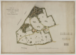
Survey drawing of estate, 1789

The survey plan or map of the Moggerhanger estate was made by E.W.Townley, a surveyor who made it at Godfrey Thornton's request. Subsequently passed on to Soane, it is elegantly drawn and shows the 123 acres of Thornton's estate with the Lodge in the centre and the Home Farm, with a detached garden building, to its right near the boundary. There are two gated entrances to the estate, a circular garden building and five ponds are shown, the boundary is hedged and fenced, the roads and tracks are fenced and partly hedged. Deciduous and coniferous trees are grouped or scattered throughout. The details of a gate and fences suggest that perhaps Townley as well as being a surveyor had a business supplying such things.
Humphry Repton made designs for the Moggerhanger estate, some of which were implemented. He produced a Red Book dated 1792 now in the care of the Moggerhanger House Preservation Trust. The park is on the English Heritage Register of Parks and Gardens of Special Historic Interest. It now consists of 53 hectares or 21.4 acres.
The small house to which Soane made a first site visit on 15 November 1790 (Soane's office 'Journal') was, in the early 18th century, a building known as 'Almonds farm' and subsequently 'Morhanger or Muggerhanger Lodge'. (English Heritage listing text via www.British Listed Buildings)
Architectural & Other Drawings results view
Select list view result
Select thumbnail view result
Architectural & Other Drawings results view
Select list view result
Select thumbnail view result