Explore Collections Explore The Collections
You are here: CollectionsOnline  /  Drawings

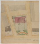
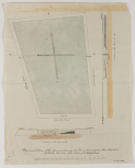
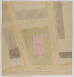
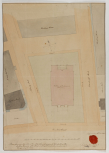
Designs and finished drawing for the site for Holy Trinity Church, Marylebone, London, August-November 1825 (4)

The site show an important change which happened in 1825. The first (SM 54/5/2) shows the Church on an east-west axis, and this seems to be a more finished drawing, but the new north-south orientation is included in pencil. The fourth (SM 54/5/4) shows the north-south orientation, but another addition in pencil nudges the the front (south end) of the Church slightly to the south-west.

The reorientation was due to the poor condition of the soil on the east-west axis, which is the widest part of the land on this location. It is also the case that the Church seems hemmed into the space, which is itself further hemmed-in by the surrounding Albany Street and Osnaburgh Road.The front of the Church is therefore accessed from the narrower side road. It could be argued orientating the Church so the entrance is on the south side and onto a major artery made the entrance more accessible. For example, now there could be a far wider carriage drive and pedestrian walkway, as well as giving a far more impressive view of the church front as it is more prominent from the main road.

The north-south orientation would not be unprecedented on the New (now Marylebone) Road. Thomas Hardwicke's earlier Parish Church was also built on a north-south axis.
Architectural & Other Drawings results view
Select list view result
Select thumbnail view result
Architectural & Other Drawings results view
Select list view result
Select thumbnail view result